Viticultural Zoning
The various definitions which attempt to come to terms with the concept of demarcated viticultural terroir, or viticultural zoning, have reflected a certain degree of nuance caused primarily by the specific conditions applicable in each country. What is clear, however, is that terroir research has agreed that territories be divided into zones in which the interactions between the vine and environmental media are as homogeneous as possible (Fregoni et al., 1998). In the Iberian Peninsula the production of quality wines takes place to a large extent in quality wine D.O. regions. In this regard, Huglin (1972) describes the concept of quality wine D.O. regions as “the delimitation of zones as those with especially favourable ecological conditions, which are, more simply put, unique.”
Because of the lack of basic data and the paucity of oenological, socio‑economic and cultural data concerning the different units of the soil medium (geo‑ referencing), a model was developed based on the terroir concept to restrict viticulture to environmentally suitable land (viticultural terroir).
Something which should be noted here is that this merely relates to components of the natural media and to the agricultural ecosystem of the vineyard, represented by the general concept of the soil (the soil series as a working unit) together with the crop and everything that pertains to the vineyard.
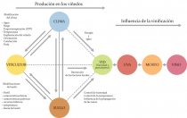
Terroir, by which we mean the vineyard environment (viticultural terroir) will be discussed below (see Fig. 158). Since the aspect of geographical demarcation is being addressed here, homogeneous environmental units need to be created. The terroir of each viticultural region with comparable limitations and potential with respect to viticultural development must therefore be defined. The soil cannot be characterised in terms of factors and properties alone; it must also be characterised in terms of geographic and cartographic distribution in order to acquire knowledge of and be able to manage such units, as well as to predict optimum conditions for quality production and differentiate other features which come to light as a result.
Benefits of Terroir Zoning
Increasingly, there are viticultural regions emerging around the world using methods such as these to play to competitive advantage. The aim is to add value to the wine, thereby positioning it competitively in the market.
The overriding goal in viticulture is the quality of the wine. Indeed, much is written about it in general articles and technical journals; the key focus is always quality, which depends on the soil and its management, cultivation, breeding, and, importantly, the selection of quality grapevine varieties.
Ultimately, it is said, the quality of the grapes depends on the interaction of environmental variables and on modifications to the system (climate, geology, topography, soil and crop) imposed by the vintner’s cultivation techniques. The oenologist for his part has to recognize that grapes in the cellar cannot be improved any further, but that he simply has to make the most of them by retaining their good properties whilst removing the unwanted elements. This is where terroir determines the characteristics of the wine. Based on experiments conducted in various viticultural regions it became apparent that by applying the same viticultural techniques within the same terroir one grapevine variety (rootstock <> variety) can guarantee a very specific type of quality wine. The need to demarcate quality viticultural regions (viticultural zoning) has its basis of proof in technical and scientific disciplines. First and foremost, it makes it easier to solve problems related to the legal protection of areas of Designated Origin, such as the use of specific viticultural techniques, the influence of the environmental impact on the wine, and the viticultural suitability and characterization of new, proposed areas of Designated Origin. It also helps clarify the issues surrounding the adoption of experimental arrangements and new technologies. These issues generate much excitement in scientific circles, and have been endorsed and validated at eight monographic congresses, beginning in 1996 in Angers (France), and every second year since then in Siena (Italy), Tenerife (Spain), Avignon (France), Cape Town (South Africa), Bordeaux‑Montpellier (France), Nyon (Switzerland) and Soave (Italy). The next Congress, planned for 2012, will be in Bourgogne‑Champagne (France).
Methodological Principle
D.O. viticultural zoning is complex, and requires a multidisciplinary methodology, involving input from viticultural experts, oenologists, soil scientists, climatologists, botanists, cartographers, statisticians and computer specialists. At the same time, the task requires countless data, which often do not exist, and the financial outlay for such an undertaking is often considerable, especially if detailed reports are needed.
There are methods available by which viticultural regions can be demarcated (See Vaudaur, 2004), even though the results may show some discrepancies. These methods involve using cartographical units with fairly homogeneous characteristics, whose details depend on the scale of the work, but which can serve as a basis for decision making. Using this methodology is not always possible, mainly because the geological data (georeferences) are not available on a sufficiently large scale. The choice of which mapscale to use is therefore an important consideration because it ultimately influences the decision‑making processes in terms of availability of material.
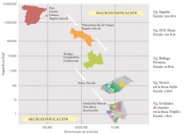
The same argument used when discussing the soil can apply. In general, there are two types of approach: the quality wine viticultural region (macrozoning) and the vineyard plot (microzoning) (Fig. 159). With small and medium scale (smaller than 1:50,000) mapping, the vineyard medium is understood as a specific ecosystem determined by its components and by the environmental factors influencing it, whereas on a larger scale map (greater than 1:25,000) these components and environmental factors can also be correlated with the quality of the wine.
In order to use these methods of D.O. viticultural zoning at the level of the small or medium mapscale, and to enable the identification and differentiation of independent sub‑zones within a region, thus allowing correlation between the specific indices in greater detail, it is necessary to combine both types of studies.
For one thing, it permits the determination of a sufficient number of precisely described homogeneous environmental units, each of which has its own precise description; for another, it allows one to arrive at which indices determine quality by means of predetermined parameters, and by means of a simplified analysis.
Small‑scale maps make it difficult to distinguish between such sub‑zones which can be unreservedly used for viticulture. This is why geological evaluation can contribute little to what is already known in respect of vineyard management problems in certain areas at high altitude, with insufficient warmth, with unsuitable lithography and physiography, and with predominantly young, badly developed soil. By the same token, even in the face of extreme opposition, the feasibility of viticulture in the traditional D.O. viticultural regions needs no justification
For modern viticulture, typicity and individuality are essential prerequisites. For a detailed characterization, we must know the conditions within which the quality wine is limited, such as the variability of the climate (mesoclimate and microclimate), topography (micro‑topography), rock type (lithological formations), and soil (series). Finally, the mapscale (microzoning) must be enlarged further.
Integrated Terroir Zoning (ZIT) on the Iberian Peninsula
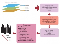
As mentioned earlier, the basis of wine production on the Iberian Peninsula is D.O. quality wine. Each D.O. region is clearly demarcated as to particular soil characteristics, size, distribution, and viticultural classification numbers. The study conducted focused on the differentiation, characterization and geographical identification of particular units within the homogeneous environmental unit. From a viticultural point of view, this is reflected in the quantities of elements and factors in the environmental media (Fig. 160).
The methodology integrates variable climatic data of the geographic situation (lithology, geomorphology, topography, and vegetation) of the soil, distribution, productivity and the emergence of vineyards as features pointing to the suitability of regional viticulture and its oenological quality. This survey has already been described in detail by others (Gómez‑Miguel et al., and Sotés et al.)
We know that the distribution of vineyards, according to their productivity, including other variables involved in viticulture (variety, origin, age, etc.) presents questionable guidelines for a survey. They should, however, be viewed as intrinsically valuable in terms of their overall development because their choice over the centuries by viticulturists has led to the most appropriate locations. The selection process is that much easier, particularly when one considers the huge amount of land available on the Peninsula and the comparatively small area given to vineyard cultivation (especially given the region’s protracted declining situation). In certain situations, however, other variables pertaining to the choice of location of the vineyard (socio‑cultural reasons, proximity to urban centres, improper agricultural planning) have led to identifiable problems which make such a choice unjustifiable, if not an exception to the rule.
The result is the map of homogeneous environmental units. The cartographic units show the principal relationships which exist between the rock groups,earth formations and soil series. Having obtained the information on the horizons survey, a geographical information system (GIS) led to the information being quantified and enabled it to be processed statistically. After that, the different stages of the levels of zoning: climate, environment, and soil are described, which give the final summary of results.
Climatic Zoning.
The influence of climate on the vegetative development of the crop and its quality has been discussed in the preceding pages. As already mentioned, climate as an expression of the influence of meteorological and geographical components on a specific physical location and at a specific point in time does not provide enough by way of description. Often, relationships between properties of the environmental media and specific features of wine quality were sought, and therefore, in order to evaluate viticultural regions, key climatic indicators were developed which took into account the conditions necessary for the proper maturation of the grapes.These indicators have limited value, are relatively irregular, suffer from the lack of direct reference to the vineyard, and from the fact that there are too few meteorological stations, or stations that are not ideally located. All these indicators serve their purpose in most viticultural regions, and restrictions exist only in terms of meso‑and micro‑climatic conditions.
This can bring with it anomalies in the normally occurring variations in climatic components which occur over the course of several years, during the season, or even daily. Such anomalies interfere with the functioning of the vineyard, although of course this does not apply exclusively to viticulture.
From small‑scale maps on a macroclimatic level, and judging from these indicators, however, these regions may be unreservedly deemed to be viticulturally suitable, and to be without significant differences (Table 2).
To illustrate this approach and evaluate it, including the small differences, the D.O. climatic zoning examines the greatest number of direct quantitative variables (precipitation, temperature, evaporation) as shown by the variables extracted (climate index, bioclimatic and viticultural specific values). In addition, by means of the correlation of the moisture balance, frost situation and heat balance and the phenological progress of the vineyard, amongst other things, a model (complete climate model) is created to provide a statistical analysis (automatic classification, discriminant factor analysis, analysis of main components) after which the variables which give redundant information are eliminated, thereby reducing the principal components of climatic information to a reasonable number (reduced climate model).
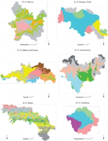
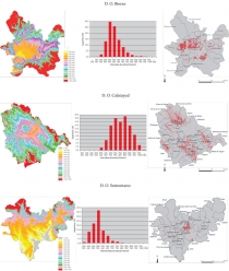
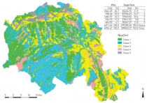
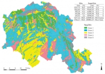
Fig. 161 shows the climatic zones of six D.O. wine regions of the Iberian Peninsula. Generally speaking, these models had their variables reduced to three (resulting in a 90% degree of probability); humidity balance, temperature, and frost were selected for the D.O. wine regions surveyed. The definitive delimitation of climatic zones is based on the plotting of these variables, or parameters, by using the digital soil model.
The Regional Demarcation of the Location, or Environmental Medium
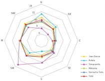
Aspects mainly related to geography (situation, continuity), topography (elevation, slope, aspect, orientation) and geology (geomorphology, landscape lithography or nature of the rock) are covered later in this paragraph, as are natural vegetation and land use, as previously discussed in the relevant section. On the Iberian Peninsula the influence of topographic elements in the majority of viticultural regions has been determined. Vineyards have already been cultivated at great height intervals, and often at extreme altitudes, although, however, with great instability/irregularity (Fig. 162), some with steep gradients and different orientations, the choice of the terrain often having been made after inadequate site analysis using technical criteria only (Fig 163). There are several factors on the Iberian Peninsula which lead to undesirable irregularities being reflected in the quality of the final product. These include the great diversity of the rock on which the vineyard develops, in a sometimes less well‑defined location within a D.O. vilicultural region, which was at times demarcated based more on administrative decisions than anything else, as well as the irregularity of the plot with poor solar exposure, together with viticultural practice that is badly adapted to the land.
Capturing these variables and factors traditionally takes place in two different ways; the first using small‑scale mapping, whilst the second is done using large‑scale maps point by point. Neither of these approaches gives entirely satisfactory solutions, since the first results in too few details, whilst the second provides no general information.
In the majority of viticultural regions under consideration, there are restrictions only in terms of the local differences in rock and soil which concern every unit (plot) and which delimit the vineyard to some extent. With small‑scale maps, however, the various D.O. regions may be considered entirely suitable for viticulture, and show no significant differences (Table 3).
The irregularities in vegetation can be observed as they are in traditional cartography whereby the amount and type of forest cover (natural vegetation), the effect of climate on the vegetation (bioclimatology), the appropriate description of the medium (potential vegetation), and its use or application (socio‑ economics) have to be taken into account. By studying these maps, priority characteristics of ecological interest and other significance can be identified; these can be pinpointed by the presence of endemic species and vegetation density.
The methodology used when demarcating environmental media (environmental zoning) or the location includes the use of detailed mapping material of the components already mentioned. In configuring a digital soil model, variables such as elevation, orientation and the length and inclination of the slope are considered. The taking of photographs and images of the area for photo‑interpretation (Forest Inventory Analysis (FIA)/soil formations and landscape) is characterised by tagging five digital references. Fig. 164 shows the FIA (geoforms) maps of the Douro D.O.C. viticultural region (SUVIDUR, 2011).
The significance of the soil maps of these units lies in previously described properties having been graphically represented. The influence of geology (geology and stratigraphy) on the binomial components of grapevine and soil corresponds to given parameters, which depend upon the type of rock and its rocky outcrops (skeletal structure).
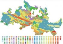
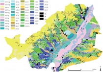
Fig. 165 shows the geographical distribution of rock formations in the D.O. Toro and D.O. Rueda regions, from which it is clear that the main production regions in the South‑West for red Toro wine and in the North‑East for white wine are easily recognisable, and relate precisely to the individual rock formations exhibited by each one.
Geographical Demarcation of the Soil
The determination of the environmental medium of the soil is amplified by soil surveys, which have been discussed in the relevant section, and which show the dependence of the soil on the terroir. This idea permits the meaningful use of a soil map (edaphic map) for zoning purposes. This fact is borne out in the majority of current and completed zoning exercises; although there are considerable discrepancies arising from the mapscale used. Regrettably, the soil is an unknown quantity for the most part, and only in a few viticultural regions, whose reputations are considerable, is there very precise data to hand. These regions have conducted detailed surveys, and soil type has been correlated with wine quality, although these results cannot be generalised because of the great diversity which exists in different soil types (Fig. 165).
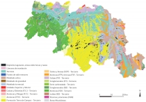
During the course of the soil survey, the methodology for demarcation of soil type, or soil zoning leads to new soil taxonomic units (STU) and soil map units (SMU), or in general, to a soil map inventory using orthodox methods (Nieves et al, 1985; Forbes et al, 1987; Wambeke and Forbes, 1988, USDA, 1993, 1994‑2010, 1999, Rossiter, 2004). The processing of the information taken from the various layers with the Geographic Information System (GIS) results in the quantification of the content, and makes statistical extrapolation possible. Fig. 166 shows the soil maps of map units for the D.O. Cigales region.
Integrated Terroir Zoning: Integrated Evaluation of Results.
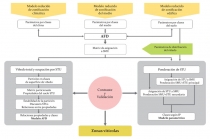
As already described, Integrated Terroir Zoning (ZIT) involves the creation of homogenous environmental units and occurs by compiling information from previous phases, and evaluating it by means of statistics (FDA – Factor Discriminant Analysis) or other methods (Fig. 164).
Mapping of the climatic zones and the three primary factors (see above) can, in addition, clarify the mean deviation (variance) on the reduced climatic zoning model, and at the same time facilitates the compilation of the digital model of the plot in respect of elevation, orientation, length/longitude and slope. The instability of the location, as well as the rock structure and the formation of the landscape are captured by the model, and ultimately, the soil series can be determined using the classic geological methods. The characterization of the media by this method and the information relative to quality is used to estimate the individual STUs.
The deciding indicator is calculated for each position (taxon), where 100% is the maximum value. The evaluation of the individual SMUs is done by averaging the weighted factors of all composite assessments (Fig. 167). Using the Factor Discriminant Analysis (FDA) statistical method, the variable potential of the range of soils is determined in order to ascertain the reasons for different uses over the plot. From this, one can assume that the degree of utilization (as a percentage) of a region for viticulture is directly related to the suitability of the soils for high quality wine. (Such soils cover a small area only and are often limited because very large zones may still have large units which have not yet been surveyed.) The various units are categorised according to “viticultural suitability of the soil” and by using FDA, all quantitative soil profile variables can be applied at the same time. Thus, common data are captured in respect of surface soil and subsoil horizons. Most of these groups of selected variables (taxa) isolated for characterization are meaningful indicators for crop yield, whilst others are also of particular interest to wine making (the K:Mg and Ca:Mg ratios, etc.). Other variables such as the organic compounds found in the C horizon influence important properties of the next horizon, which is closely linked to the litholosphere. A comprehensive survey including the C horizon yields more meaningful indicators than a survey of just the two upper horizons. The FDA, in conjunction with other statistical methods (such as the linear combination of analytical properties) serves to categorise each of the groups (taxa) spatially, in order of proximity. Providing the results are sufficiently similar the final result is achieved by validating and juxtaposing these two methods. From these results, the indicative differences in terms of their suitability for grapevine cultivation become immediately apparent in the various STUs. This clearly has variable consequences when establishing a vineyard site; some sites are planted to intermediate crops, whilst others are definitely excluded from viticulture. Moreover, these relationships exist regardless of the available area.
ZIT Information: Field of Application
The data created by the ZIT study is georeferenced, digitally scanned and incorporated with a substantial Geographic Information System (GIS). It is linked, as is to be expected, to the properties of each of the components: climate, topography, geomorphology, lithology, vegetation and land use, vineyard mapping information, the soil, and finally, terroir zoning.
It also includes a software utility, which registers the plots, the orthophotographic physical inventory and administrative data (such as D.O., vintner, etc.), and where applicable, the D.O. administrative body (e.g. CRD.O., INDP). Managers of wineries, cooperatives, and even producers and other parties involved have access to these data.
Integrating the systematically demarcated and characterised areas within a viticultural terroir into a GIS enables not only easy access to all information via the network and efficient updating (high and low planting, control of age, training system, production, quality, etc.), but also provides access to information on yields, cultivation method, methods employed with new plantings in existing vineyards that provide better quality, and where, for some reason, vines have not previously been planted.
With regard to experiments which are required in compliance with vinification criteria for homogeneous environmental units (cf. Gonzalez‑ Sanjose et al, 2008), ZIT allows the optimal selection of the location of the test site such that the results can be generalized, making comparison with other areas possible (selection of regions with no viticultural tradition), and ultimately facilitating technology transfer.
Knowledge of utility computing in agricultural circles is improving significantly, since the data on environmental media enables individual producers to glean technical information on climate, geology, soils, and, last but not least, information on the ZIT terroir‑quality index, thereby pointing them in the right direction.
The ZIT programmes and data give the wine estate the means with which to optimise soil management and yield (Table 4). In any case, some details are imperative, particularly in regard to the scale of the studies (Fig. 159) undertaken as indicated in the definitions of macrozoning (smaller than 1:50,000) and microzoning (larger than 1:25,000), and as discussed in the section on soils.
With macrozoning it is common for several terroirs to be summarised in one map unit. This fact, which has little impact on applications already described, is of crucial importance in terms of agricultural management. For this reason it is essential, especially for tasks related to both traditional viticulture and precision viticulture (Table 4) that surveys are conducted separately for each of the terroirs concerned, and the scale of the study enlarged (microzoning) until each cartographic unit encompasses a single terroir only.
In this sense, microzoning is the place where the soil‑crop‑product relationship is managed through continual monitoring of the variables at every stage of production. Thus, the monitoring and optimization of all sections within the structure of a regional macrozoning are guaranteed. Monitoring and optimization includes the place and geometry of vineyard planning, suitable stock, relationships between the soil and plants: effects of physical and chemical properties (health and development), as well as the efficient utilization of inputs when cultivating homogenous units. This allows the extrapolation of results and the identification and characterization of homogeneous environmental units with its concomitant direct influence on environmental issues and regional development. Finally, monitoring the variables of each managed unit (series) determines the ecological relationship to plants and the grape, and, of course, wine quality.
Conclusions and Prospects
Complete Integrated Terroir Zoning (ZIT) in the context of this section enables the demarcation and characterization of homogeneous environmental units with respect to geography, climate, geology, geomorphology, and the soil in terms of its products (grapes, must) which leads to the production of quality wine.
In this sense, ZIT actively and successfully takes on the challenge facing quality viticulture on the Iberian Peninsula. Its role is clear: to characterize the quality wine regions and demarcate them accordingly. Zones vary according to the quality of the product: what is required is the management of proper viticultural techniques, the creation of vineyard feasibility studies in regions where no viticultural tradition exists (Gómez‑Miguel, 2005), and the selection of trial areas in predefined regions where optimum exploration can take place, the results of which can be generalised and transferred to other comparable, defined plots by means of technology transfer. Here, the availability of GIS is of prime importance, not least because its operating data can be used to draw up homogeneous taxonomic units (microzoning).
ZIT also has a role in agricultural extension and provides a direct source of information for viticulture. Computers lend support by means of the Geographic Information System which provides easy access to climatic, lithological, geomorphological, topographical and pedological data. The database is continuously growing as it is being used, and updated with information from more and more vineyard plots. This information makes it easier to improve conventional viticultural practice and provides the necessary tools for the efficient operation of the modern vineyard (precision viticulture), which aims to reduce costs through the refinement of technique.


